|
ABOUT ROORKEE CITY AND ROORKEE CANTT.:
(A.) History:
Rorkee is of some antiquity and is said to derive its name
from RURI, the wife of a rajput chieftain. Roorkee was spelled as RURKI in 1887 edition of the Saharanpur Gazetteer. According
to Ain-i-Akbari (Author - Abul Fazal), RURKI or ROORKEE was the capital of a Pargana (Mahal) in the time of Emperor Akbar,
but was reduced in stature in the time of Zabita Khan with the formation of Sakrauda, the estate of Rao Qutb-ud-Din. From
about the middle of 18th century, it was included in the estate of Gurjars of the small estate of Landhaura (Near Roorkee),
and remained in their possession till Raja Ramdayal died in 1813. In British occupation, it was a mere mud-built village.
The growth of Roorkee as it exists today can be said to have started in 1840 when construction of Ganga canal was undertaken.
Thereafter, the things moved very fast with establishment of Engineering Workshop, Churches, Schools, Engineering College
and Cantonment etc.
Solani Aqueduct constructed more than 150 years ago to take the Ganga canal across Solani
River, is less than one km. away and is considered a brilliant engineering fiat.
(B.) Location:
Roorkee is located on National Highway (NH) - 58 (Delhi-Haridwar/Dehra
Dun-Shri Badrinath-Mana Pass) and NH-73 (Panchkula/Chandigarh-Yamuna Nagar-Roorkee). Roorkee comes under Norhtern Railway
and is well -connected by trains (Shatabdi, Jan-Shatabdi, Mail/Express and Shuttle/Passenger) with a number
of important Indian cities including Delhi, Mumbai, Kolkata, Chennai, Ahemedabad, Jaipur, Lucknow, Bhopal, Gwalior, Agra,
Ujjain, Indore, Dhanbad, Patna, Jammu, Puri, Amritsar, Dehra Dun etc.
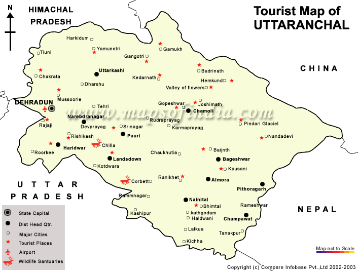
Plate: Tourism Map of Uttarakhand (Formerly Uttaranchal)
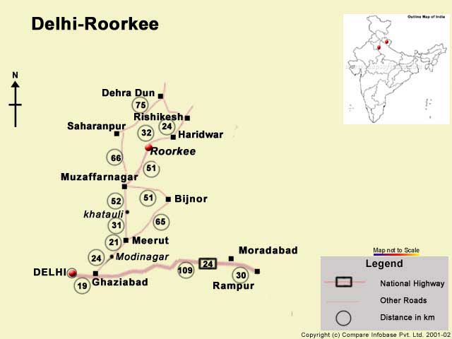
Plate: Delhi - Roorkee Road Map
Roorkee is the entrance town (from Delhi) to various destinations
of Uttarakhand including the Char-Dham (Gangotri, Yamunotri, Sri Badrinath and Sri Kaidarnath), holy places like Haridwar,
Rishikesh, Uttarkashi and hill stations of Mussorie (Popularly known as Queen of Hills) and Dhanolti. The state capital Dehra
Dun is about 75 kms. from here via road and about 100 kms. via rai.. From about 50 kms. from here, Mountain kingdom of Uttarakhand
Himalaya begins.
You may reach here from any of the following important trains:
01. New Delhi - Dehra Dun
(Shatabdi Express)
02. New Delhi - Dehra Dun
(Jan Shatabdi Express)
03. New Delhi - Dehra Dun (A/c Special Express)
04. Chennai - Dehra Dun/ Chandigarh
Link Exp. (S/F Express)
05. Mumbai/ Bandra - Dehra Dun (Dehra Dun Express)
06. Chandigarh - Muzaffarpur (Harihar
Express)
07. Jammu Tawi - Guwahati (Lohit Express)
08. Chandigarh - Lucknow (Chandigarh
Express)
09. Dehra Dun - Okha
(Uttarakhand Express)
10. Gorakhpur - Jammu Tawi
Exp. (Amarnath Express)
11. Jammu Tawi - Barauni (Amarnath Express)
12. Amritsar - Howrah (Punjab Mail)
13. Puri - Haridwar
(Kalinga – Utkal Express)
14. Indore - Dehra Dun (Intercity
Express)
15. Sriganganagar
- Haridwar (Intercity Express)
16. Amritsar - Dehra Dun (Lahori
Express)
17. Dhanbad - Firozpur
Cantt. (Ganga-Satluj Express)
18. Sahranpur - Lucknow (Saharanpur
Express)
19. Ujjain - Dehra Dun (Ujjayani
Express)
20. Sealdah - Jammu Tawi (Sealdah Express)
21.
Jammu Tawi - Rishikesh (Hemkunt Express)
22. Howrah – Amritsar (Howrah Express)
23. Barmer
- Haridwar (Link Express)
24. Ahemadabad - Delhi - Haridwar (Delhi Mail)
25. Amritsar - Howrah (Jaliyaanwalabagh Express)
26. Dehra Dun - Kochuveli Super Deluxe Express
27. Saharanpur - Lucknow (Passenger)
28.
Delhi - Haridwar (Passenger)
29. Moradabad - Saharanpur
(SM – Passenger)
30. Dehra Dun - Saharanpur
(DLS – Passenger)
31. Delhi - Delhi
(Passenger)
32. Kaliyar Mela Special (Lucknow/Moradabad –
Roorkee/Saharanpur) (*During Annual Urs at World Famous Dargah - E - Kaliyar Sharif – Near Roorkee)
(*In addition, some more trains are available for all over India from nearest important stations/ junctions viz. Saharanpur,
Laksar and Haridwar)
PHOTO GALLERY - ROORKEE
Plate: Main Building, Indian Institute of Technology,
Roorkee
Plate: The World Famous Dargah - E - Piran Kaliyar -
A Symbol of Unity
Plate: Students at Jawahar Bhavan Hostel, IIT Roorkee - Holi Celebrations
Plate: A Class at Roorkee School for the Deaf
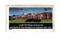
Plate: Postal Stamp, released by Government of India, on the occasion
of Sesquicentennial Celebrations (150 Years) of earstwhile University of Roorkee (Now IIT Roorkee)
(C.) Geographical and Meteorological Parameters:
Roorkee
is located at 29 Deg. 51 Mins. N and 77 Deg. 53 Mins. East on the south bank of Solani River. The Upper Ganga Canal is the
most important features and adds beauty to the city. Running from north to south, it divides the city in two distinct parts.
Important geographical and meterolocical parameters of the city are as follows:
01. Latitude : 29 Deg 51 Min N ; Longitude : 77 Deg 53 Min E
02. Altitude : 274 Meters AMSL (Above Mean Sea Level)
03. Averate Annual Rainfall : 1068 mm
04. Average Monsoon Rainfall : 878 mm
05. Heaviest Rain in 24 Hrs. : 286 mm (1880)
06. Average Max. Temperature : 40 Degree Celntigrade
07. Average Min. Temperature : 2 Deg. Centigrade
08. Average Max. Humidity : 100 %
09. Average Min. Humidity : 30 %
10. Average Annual Potential ET : 1340 mm
11. Average Annual Wind Speed : 4.9 m/s
12. Average no. of days with Fog : 15 days
13. Average no. of days with Thunder : 39 days
14. Average no. of days with Hail : 2 days
15. Average no. of days with Duststorm : 3 days
16. Highest Temp. : 46.7 Deg Cent (June 13th, 1932)
17. Lowest Temp. : -2.2 Deg Cent (February 02nd, 1905)
(D.) Important Academic Institutions:
01. Indian Institute of Technology (IIT-R) (Formerly University of Roorkee)
02. College of Engineering Roorkee (COER)
03. Roorkee Institute of Technology (RIT)
04. K.L. Ploytechnic (KLP)
05. Roorkee Institute of Medical Sciences (RIMS)
06. Roorkee College of Pharmacy (RCP)
07. Bishambhar Sahai Law Institute (BSLI)
08. B.S.M. Law College
09. Institute of Management Studies (IMS)
10. District Institute of Education and Training (DIET)
11. Roorkee School for the Deaf
12. B.S.M. Post Graduate College
13. K.L.D.A.V. Post Graduate Colege
14. S.D.P.C. Girls Degree College
15. Methodist Girls Degree College
16. Seventh Day Advantist College
17. Babu Ram Degree College
18. Roorkee Degree College
19. Arihant College of Education
Besides, a number of Sr. Sec./Sec. Schools are located in the city for better
education.
Available academic programmes in the city:
General Education: Pre - Nursery to Sec./Sr. Sec.: All Disciplines
Humanities: Sec./Sr. Sec. to Ph.D./ Post Doctorate Levels
Sciences: Sec./ Sr. Sec. to Ph.D./ Post Doctorate Levels
Computers: School Level to Ph.D./Post Doctorate Levels
Engineering: B.E./B.Tech. to Ph.D./ Post Doctorate Levels
Management: Graduation to Ph.D./ Post Doctorate Levels
Commerce: Sec./Sr. Sec. to Masters Levels
Medical: At present Pharmacy and Pathology related programmes
Hotel Mgt. & Tourism: Diploma to Post Graduate Levels
Degree Programmes Available in City: School Level Education (Pre Nursery to XII Standard),
B.A./M.A., B.Sc./M.Sc., B.Com./M.Com., B.B.A./M.B.A., B.C.A./M.C.A., B.E./M.E., B.Tech./M.Tech., Diploma/P.G.Diploma, B.Lib./M.
Lib., L.L.B. , Ph.D./Post Doctoral Programmes.
(E.) Research and Professional Organisations:
1. Central Building Research Institute (CSIR, Govt. of India)
2. National Institute of Hydrology(M/o of Water Resources, GoI)
3. Irrigation Reserach Institute (Under State Govt.)
4. Irrigation Design Organisation (Under State Govt.)
5. State Govt. Engineering Workshop (Under State Govt.)
(F.) Roorkee Cantonment:
Roorkee Cantt. is the Head Quarters of the Indian Army's BENGAL ENGINEERING GROUP AND CENTRE/BENGAL
SAPPERS (Affectionately called as God's Own). The BEG & C have the unique distinction of being the only army's group affiliated
with both the Navy and the Air Force. The acievements of the group during times of peace are no less renowned than those during
war. It won laurels by constructing the Upper Ganga Canal , building roads and bridges at high altitudes and undertaking the
management of natural calamities and disasters in different parts of the country. Important projects undertaken by the group
include construction of Upper Ganga Canal, The Thomason Engineering College (Now IIT Roorkee), The trunk road between Kolkata
and Nagpur and the GT Road.
The BEG & C Roorkee is one of the oldest army units of the country and has become a legend
of valour, service and sacrifice. Capt. Tom Wood raised Bengal Pioneers in Kanpur (U.P.) in 1803. After this, Bengal Sappers
was founded in 1819. Afterwards, both these organisations were merged into one known as BEG & C and it's head quarter
was established at Ludhiana (Punjab), which later on , in 1853, was shifted to Roorkee, now known as BEG & C Roorkee,
Bengal Sappers Roorkee or Roorkee Cantt.
The BEG & C Roorkee has the proud distinction of earning hundreds of coveted honours
and military awards including Padm Vibhushan, Padmshri, Victoria Cross, Military Cross, Indian Order of Merit, Very Special
Medal, Special Service Medal, Kirti Chakra and Arjun Awards, during war times.
(G.) Select Festivals of Roorkee:
(01.) CONFLUENCE: CONFLUENCE, the foreign student’s day at IIT Roorkee is celebrated each
year . It’s virtually a confluence of the multi-dimensional and rich cultures of Afro-Asian and Latin American
countries vivified through songs and folk dances by the foreign students studying in IIT Roorkee. There are about 150 seats
in different disciplines of engineering and technology, applied sciences, management and social sciences in IIT Roorkee for
a number of countries including Bangladesh, Nepal, Bhutan, Indonesia, Ethiopia, Middle East countries, Venezuela, Magnolia,
Uzbekistan, African countries etc. The CONFLUENCE, which is held every year, is dedicated to the memory of the great educationist
and first education minister of the country, Maulana Abdul Kalam Azad. The cultural items presented by the foreign students
have themes like romantic love and love of the country. Though the foreign students sing in alien languages, their songs find
their way into the responsive hearts of the listeners who fully grasp their meaning, though they don’t understand the
language. The aim of organizing this event every year is to build bridges of understanding and promote cultural integration
by bringing the students of different countries in touch with what is best in the cultures and traditions of these countries.
(02.) COGNIZANCE:
Cognizance - is the mega techno-festival of IIT Roorkee, organized
each year around March. A number of students of technical institutes and universities from all over the country participate
in the mega event. The main attractions of the festival include paper presentation by renowned scholars, guest lectures by
eminent personalities from corporate houses, debates, quiz competitions, etc.
(03.) SHRISHTI:
The Annual All India Techno - Hobby Festival / Annual Exhibition is organised by Hobbies Club, IIT Roorkee. It includes the
sections related to hobbies/ interests from different walks of life viz.: Philately & Numismatics, Gardening, Star Gazing
(Space Sciences), Web Designing, Model Section, RANGOLI, Photography, Fine Arts etc. It attracts students from all over India
and also public in both Members and Guest Categories.
(03.) THOMSO: Thomso -
the annual festival of Youths at IIT Roorkee attracts students from all over India, especially from Engg. Colleges/Universities.
Its celebrated in the memory of JAMES THOMASON (The man behind the Thomason College of Civil Engg. - Later upgraded to Thomason
College of Engg. - Roorkee College - University of Roorkee - and Finally the 7th and Youngest IIT of the nation with longest
history.). The Thomsonians - as the University of Roorkee students have been designated in past (Though they are treated as
IITians now a days - they are still Thomsonians by spirit!!!) invite students from All over India in this Youth festival.
(04.) INTER IIT - GAMES:
On a rotation basis IIT Roorkee organises Annual Inter IIT Games (Rotation Process: IIT Delhi, Madras/ Chennai, Bombay/
Mumbai, Kanpur, Kharagpur, Guwahati and Roorkee).
(05.) TAYA JI MEMORIAL
ANNUAL VOLLEY BALL TOURNAMENT: This national level annual volley ball tournament is organised sometime around
Feburary - March by the organising committee and attracts fine national teams from Railways, ONGC, State Police Departments
and various other national/ state level organisations.
(6.) PUSHPANJALI:
The Annual Flower Show of Bengal Engineering Group & Centre (BEG & C) is celebrated in Bi - Centenary Grounds in Roorkee
Cantt. (Around Jan./Feb.)
(7.)
Flower Show, NIH: National Institute of Hydrology (NIH) organises annual flower show sometime in winter/early summer.
(08.)
Flower Show, CBRI: Central Building Research Institute, Roorkee organises annual flower show sometime in winter/
early summer.
(09.)
Flower Show, IIT Roorkee: Indian Institute of Technology also organises its flower shows through (a.) Hobbies Club,
IIT Roorkee All India Hobbies Festival / Exhibition (Gardening Section) and (b.) Afro Asian Hostel.
(H.) Roorkee
School for the Deaf:
Deafness is considered a curse.
The Roorkee School for the Deaf has been working to fight this curse. Situated in IIT Roorkee premises, this school is running
in nearly ½ - hecatare land with a sound infrastructure. Though it has no affiliation
with the IIT Roorkee, off and on it does use the multi-purpose vast resources of IIT. The school has been started in 1989
and is dedicated to the cause of education for deaf and dumb children. Today, the school imparts education to around 60 students,
from LKG to 12th standards. The school follows the CBSE standard of education. But examinations for secondary and
higher secondary classes are conducted by the National School of Open Learning, Delhi. Equipped with very ultra modern electronic
gadgets and facilities, a team of around half-dozed teachers provide innovative exercises like auditory training, lip reading,
whole language approach and self-instruction learning exercise to the students. The curriculum for each child is individually
designed and so planned that the residual potential gets fully harnessed. The resultant outputs from the students are very
encouraging.
(I.) IIT Roorkee's Central Library:
The Central Library of IIT Roorkee finds a unique place
among the Higher Education Libraries. The library was established in 1848 to support the academic activity of the newly established
College of Civil Engineering (1847). In 1860, the Library of the Adiscombe College of London and Ganga Canal Library were
merged into the College Library. It was rechristened as Central Library in 1862. Started with a couple of hundred books the
collection of the library has grown up to more than 2,75,000 documents. Though it is prominently a science and technology
library, its collection is equally strong in humanities and social sciences. A number of research scholars from all over the
country visit the library every year. This library is a rare amalgamation of the old and the new. On one hand it maintains
an excellent archive, on the other hand it uses latest information technology tools in its services. The archives of the library
contains more than 5000 documents including world famous ROORKEE TREATISES, handwritten notes of the teachers of the College
of Civil Engineering (1846 – The first engg. College of Asia , established in Roorkee), books and other documents printed
during 17th and 18th century, the personal collection of Sir. P.B.Cautley (the brain behind the Ganga
Canal) etc. Recently the Archival Section has been renovated and has controlled climate to ensure the longevity of the documents.
The Library have Computer and Internet facilities and LAN. All resources are searchable from the campus-wide network.
(J.) Drawing and Survey Instruments
Industry of Roorkee:
Roorkee’s and
drawing and survey instruments manufacturing units have given it a unique identy. During the British rule, for about half
a century, Roorkee remained a an exclusive centre for the manufacture of survey instruments. After independence some units
were established in Ambala (Haryana) and Kolkata (West Bengal), but despite all governmental assistance, these units have
not been able to stand on their own. As a result, even today, Roorkee continues to be the centre for the manufacture of survey
and drawing instruments. The construction of the Ganga Canal, establishment of the Thomason College of Engineering and later
the Bengal Engineering Group and Centre Headquarters in Roorkee gave the needed fillip to the survey instruments industry.
Af first, the British had to import even small survey instruments from London. Later, some local people were trained to repair
these instruments. Till 1857, the survey and drawing instruments industry had found its feet here. The local people had put
up dozens of small scale units in the city. There are about 75 big and small survey and drawing instruments units which produce
instruments of crores of rupees annually. Roorkee as it is likely to hit the booming export-oriented industry with an annual
exports worth over Rs. 70 crore. Most of the production is for exports to UK
and USA. Domestic demand include the technical and higher education institutions including IITs and NITs and select research
and professional institutions.
(K.) The Wetland of Bann Ganga:
Come winter and thousand
of winged guests, both from Palaearctic countries of Europe and Asia and the local Himalayan region, arrive at the old Upper
Ganga Canal near Roorkee, the wetland of Bann Ganga near Laksar and Bheem Goda
barrage for their wintry sojourn. It is to be mentioned that in winter when there is no germination in nature, thousands of
fowls from the trans Himalayan region such as Siberia descend on the tropical wetlands in the this region of Uttaranchal in
search of food and shelter. More than two dozens of species of migratory birds had so far been identified in the wetlands
of the region. Prominent among the trans Himalayan migratory birds to which the wetlands of the district play host are spot
bills, gulls, marlards, pochards and sholducks. Besides the trans-Himalayan migratory birds, these wetlands are also the destinations
for the local Himalayan birds such as herons, wagtails, and cormorants during winter season. Taking cue from their inbuilt
biological clock and guided by their unfailing sense of direction, the migratory avifauna descend on these wetlands in November
and December and depart for their native habitats in March.
(L.) College of Engineering Roorkee (COER):
Want to pursue a specialized course in Robotic Engg. Or for that matter; in Biomedical Engg. Or Microelectronics?
If you though thtat for such courses you’d have to go abroad, then think again. All these and more are now available
at the COER. Established in 1999, the college is affiliated to Uttar Pradesh Technical University, Lucknow , and is approved
by the All India Council for Technical Education, New Delhi. Spread over about 75 acres of land, the college campus is on
NH 58 and is a mini city that is coming up very well. The institute aims at producing technical professionals with a temperament
for sound logic and strong morals. There is a full-fledged faculty of about 40 members, most of whom are PGs from the IITs,
with vast teaching as well as industry experience. Visiting faculty from across the country is also invited. The institute
offers B.Tech. in select disciplines and select PG Programmes including MCA.
Related Websites : http://haridwar.nic.in/, http://gov.ua.nic.in/
**UTTARANCHAL - LAND OF GOD*
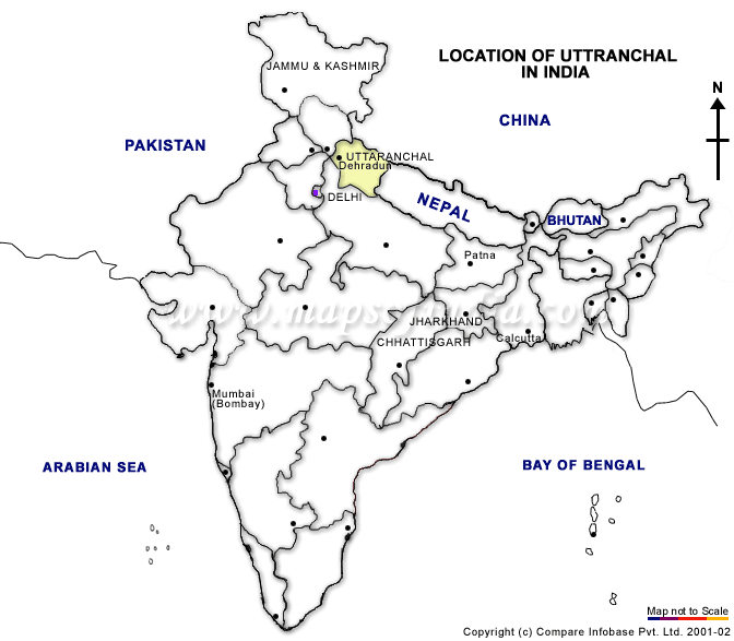
Plate: Location of Uttaranchal State within India
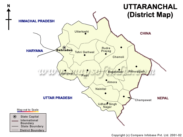
Plate: District Map of Uttaranchal
GENERAL INTRODUCTION TO UTTARANCHAL
Situated in northern part of India, Uttaranchal is surrounded by Tibet & Nepal
in the North, Madhya Pradesh in the South, Haryana, Delhi & Rajasthan in the West and Bihar in the East. Dehradun,
Mussoorie, Nainital and Ranikhet are the valleys with immense natural beauty.
The sacred river of Hinduism, the
Ganges flows through holy places in Uttaranchal. Uttaranchal is a scenic state, which has got many hill stations sprinkled
along the foothills of the Himalaya. The place has many excellent trekking routes and countless other tourist destinations.
1.  DEHRA DUN DEHRA DUN
Dehradun - the capital of Uttaranchal, is one of the oldest cities in India. The
salubrious climate of the city makes it a hit tourist destination among the tourists.
The city includes countless destinations to visit. In addition to this, Jhanda Fair
and Lakhawar Fair offer a variety of events that include folk dances, music and sport competitions.
Dehra
Dun is also famous for Indian Milatary Academy (IMA), Wadia Institute of Himalayan Geology, Forest Research Institute etc.
Sight Seeing: Sahasradhara,
Tapkeshwar Mahadev Temple, Paltan Bazar, Rajaji National Park, Dak Pathar
How to Reach: Dehra Dun,
the capital of Uttaranchal is connected by Air, Rail and Road Network with all parts of the Nation. Dehra Dun Airport is situated
at Jolly Grant. Besides Dehra Dun is a rail head which is connected with many important cities by direct trains. Direct train
services are available to cities like Delhi, Chennai, Kolkata, Mumbai, Lucknow, Amritsar, Ujjain, Indore, Ahmedabad, Bhopal
etc. There are two important bus stations one of which offers bus services to the hilly regions of Uttaranchal while
the second one i.e. Inter State Bus Terminus (ISBT) provides services to all important cities and towns of the region and
nearby states.
Photo Gallery - Dehra Dun
 
Plate: Clock Tower Plate:
Jhanda Fair, Sri Guru Ram Rai Temple
 
Plate: Jhanda Darbar
Plate: Rajaji National Park
 
Plate: Asan Barage
Plate: Dak Pathar
 
Plate: Sahasradhara Plate:
Lachiwala
 
Plate: Santla Devi Temple Plate:
Balani Devi Temple
 
Plate: Kempty Fall
Plate: Forest View
 
Plate: Ram Jhula, Rishikesh Plate: Sacred
Ganga at Rishikesh, Rishikesh
Mussoorie
Located at a height of 2000 mete,rs, this picturesque hill resort was set up during
the days of the "Raj". It's treks and walks down the famous Camel Back Road welcome visitors in the summer and in the winter.
For the Angler, fishing is available for Trout or Mahsee.
Sight Seeing:
Gun Hill, Camel's Back Road, Kempty Falls, Lal Tibba, The Jheel
 
Gun Hill, Mussorie Mussorie Road, Dehra Dun
 Dhanaulti Dhanaulti
Situated on the Mussoorie-Chamba route, Dhanaulti is 31 kms
from Mussoorie via Landao Bazar. It is located amidst thick, virgin forests of deodar, rhododendrons and oaks. The long wooded
slopes, lazy outings, cool caressing breeze, warm, lovely weather and fabulous view of snow covered mountains makes it an
ideal retreat for a relaxed holiday.
Sight Seeing: Surkanda Devi, Chamba and New Tehri.
2. NAINITAL
Nainital is a glittering jewel in the Himalyan necklace, blessed with
scenic natural spledour and varied natural resources . Dotted with lakes , Nainital has earned the epithet of
'Lake District' of India . The most prominent of the lakes is Naini lake ringed by hills . Nainital
has a varied topography . Some of the important places in the district are Nainital , Haldwani , Kaladhungi
, Ramnagar , Bhowali , Ramgarh , Mukteshwar , Bhimtal , Sattal and Naukuchiatal . Nainital’s unending
expense of scenic beauty is nothing short of a romance with awe-inspiring and pristine Mother nature.
Nainital is a lake resort set at a height of 1,938 meters in a beautiful valley.
Surrounded by seven hills, the sparkling waters of a natural lake make it a gem among hill resorts. Legend has it that the
lake was formed when the Goddess Sati lost her eyes at this spot.
Sight Seeing: Naini Lake, Snow View, Naina Peak, Hanuman Garhi
How to Reach: Naintal is well connected with
the rest part of country through different modes of transportation. The nearest Airports are at Pant Nagar and Jolly Grant
(Dehra Dun). Nearest Railway Stations are Haldwani and Kathgodam which are connected with important Indian cities including
Delhi and Kolkata. Nainital is also connected by road network through different parts of the region.
Photo Gallery - Nainital
Plate: Naina Devi Temple and Naini Lake, Nainital
Plate: Mall Road, Nainital
Plate: Aerial Ropeway, Nainital
Plate: Governor's House (Raj Bhavan)
Plate: Aryabhatta Research Institute of Observational Sciences (ARIES)
Plate: Dorothy Seat and Tiffin Top
Ranikhet
It reflects the best of the heavenly Himalayas; their lush green forests, exotic
plant life, attractive wild life and majestic mountain peaks.  According to a popular belief, this place had won the heart of Rani Padmini, Queen of Raja Sudhardev. She chose this scenic
place to be her abode and since it has come to be known as Ranikhet, literally "Queen's Field". The invigorating mountain
breeze, the singing of birds, the panoramic view of the Himalayas - the sights, sounds and smells leave the onlooker spellbound.
During the rain, flowers cover the valley and as winter comes, the soft falling snowflakes cover the environs in sheets of
pure whiteness. Ranikhet is an all season destination. Sight Seeing: Chaubatia,
Bhaludam, Jhoola Devi Ram Mandir, Mankameshwar, Upat and Kalika, Hairakhan Temple, Tarikhet, Binsar Mahadev, Majkhali, Dwarahat,
Chaukhutia, Bhikiasain, Manila, Naithna Devi Jaurasi, Khairna and Pandukholi.
3. ALMORA
Almora, is situated between Kaushiki (Kosi) and Salmali (Siyal) rivers.
This is the birth land of several noted freedom fighters, intellectuals, technocrats and bureaucrats. This place has been
the prime administration center for the Chanol Kings, Gorkha invaders and British colonialists.
Almora, a picturesque district in the Kumaun
region, East of Uttaranchal in India, with a breathtaking panoramic view of Himalayas, summons tourists worldwide to its alluring
grandeur of natural beauty.
Famous for its rich cultural heritage, unique handicrafts, sumptuous cuisine
and magnificent wildlife, coupled with an easy accessibility, Almora promises its tourists a visit full of fun and unforgettable
moments.
Quaint hill resorts such as Chaukori, Ranikhet, Sitlakhet, Binsar, Kausani, Jageshwar
and Bageshwar are all around Almora which attract nature lovers.
Sight Seeing:
Public Museum, Nanda Devi Museum, Bright & Corner, Deer Park, Chetai Temple, Simtola
How to Reach: Almoral is well connected with
the rest part of country through different modes of transportation. The nearest Airports is at Pant Nagar . Nearest Railway
Stations are Haldwani and Kathgodam. Almora is also connected by road network through different parts of the region.
Photo Gallery - Almora

Plate: Chitai Temple

Plate: Baijnath Temple, Baijnath Town, Almora District

Plate:
Jageshwar - The Abode of one of the 12 'Jyotirlings'

Plate: Beautiful landscape of snow covered Himalayan Landscape from
Kausani town
Kausani
1890 meters above sea level, Kausani, provides a breathtaking view of the snow capped
peaks of Panchchuli, Nandakot, Nanda Devi, Trishul, Nanda, Ghunti and Chaukhan. The famous Hindi poet Sumitra Nandan Pant
and the famous folk singer Gopidas belong to Kausani. Gandhiji wrote a book 'Ana-Shanti Yoga' as he was impressed by the serenity.
Sight Seeing: Annashakti Ashram, View of the Nanda
Devi Hill
Haridwar
A paradise for nature-lovers, Haridwar
presents kaleidoscope of Indian culture and civilization. Haridwar also termed as 'Gateway to Gods' is known as Mayapuri,
Kapila, Gangadwar as well. The followers of Lord Shiva(Har) and followers of Lord Vishnu(Hari) pronounce this place
Haridwar and Haridwar respectively as told by some. It is also a point of entry to Dev Bhoomi and Char Dham (Four
main centers of pilgrimage in Uttaranchal) Viz. Badrinath, Kedarnath, Gangotri and Yamunotri.
Sight Seeing: Sri
Ganga Arti at Har-ki-pauri, Bharat Mata Mandir, Sri Mata Veshno Devi Temple, Maa Mansa Devi Temple and Aerial Ropeway, Maa
Chandi Devi Temple and Aerial Ropeway, Rajaji National Park and many other temples and picturesique locations around Sacred
Ganga.
How to Reach: Haridwar is well connected
to rest of the nation through road, rail and air transport. The nearest Airports is at Jolly Grant (Dehra Dun). Railway
services are available from here to a number of important Indian cities including Delhi, Kolkata, Chennai and Mumbai. Haridwar
is also connected with a number of important cities in the region.
Photo Gallery - Haridwar
Rajaji National Park, Uttaranchal
Sacred Ganga at Haridwar
Select Temples at Haridwar
Besides the aforementioned districts, all remaining districts also have a number of religious places and picturesque
locations. Detailed information may be obtained from Internet (Recommended Websites: www.uttara.in, www.gov.ua.nic.in, www.uttaranchal.nic.in )
PHOTO GALLERY - UTTARANCHAL
|